
Balanced Development will benefit Environment and Community
We have worked through a deliberate long-term master plan that will set this neighbourhood apart. A keen regard for nature and a strong emphasis on preservation respects the natural environment while allowing for the creation of a unique residential community. The increased supply of 90 single family lots will improve affordability and increase available housing in the Elk Valley.
Commitment to Our Community
We know residents treasure the summer and winter trails on the Galloway Lands. We are working with respected local recreation groups to ensure the multi-use trails are thoughtfully developed and managed.
We are proud to announce that we are dedicating 50% of our land, 232 acres of natural space, along Lizard Creek to trust. This dedication will preserve the environment and maintain recreational trails in the area.
As well, Lizard Creek will be protected by setbacks that exceed all municipality and provincial requirements. This watershed is not currently protected. Our proposal will ensure the forested areas are never clear cut again.
Learn more about the specifics of the plan here.
- click on image to zoom
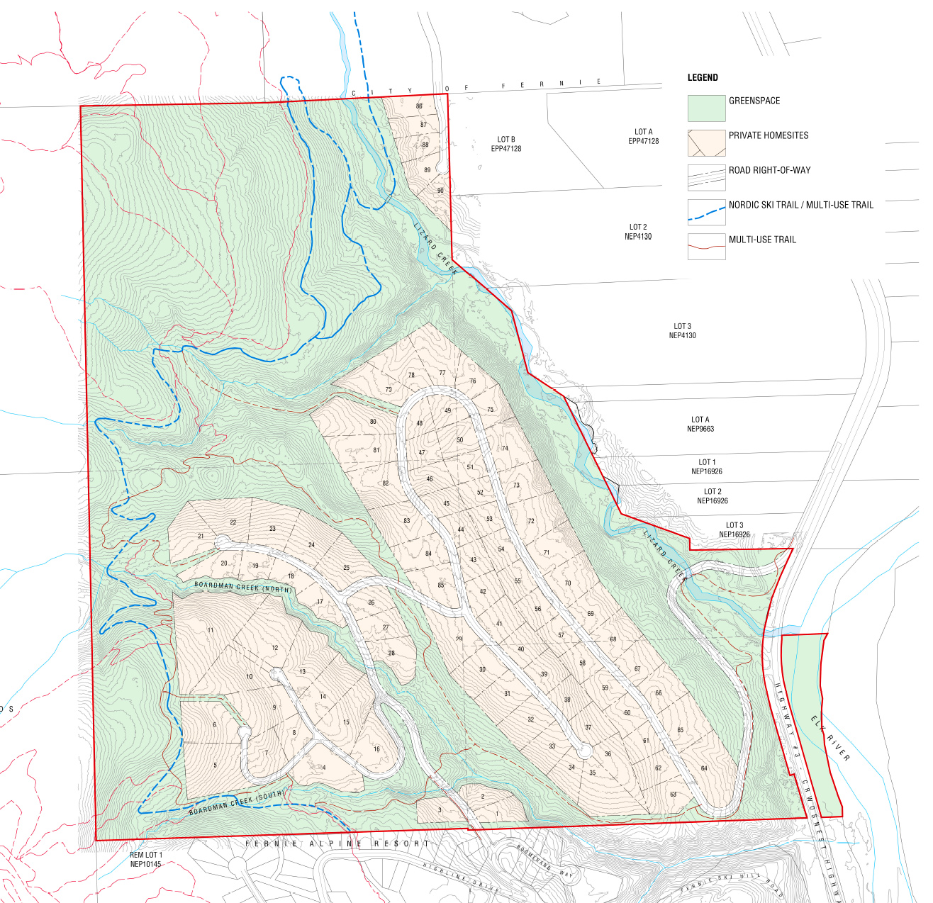
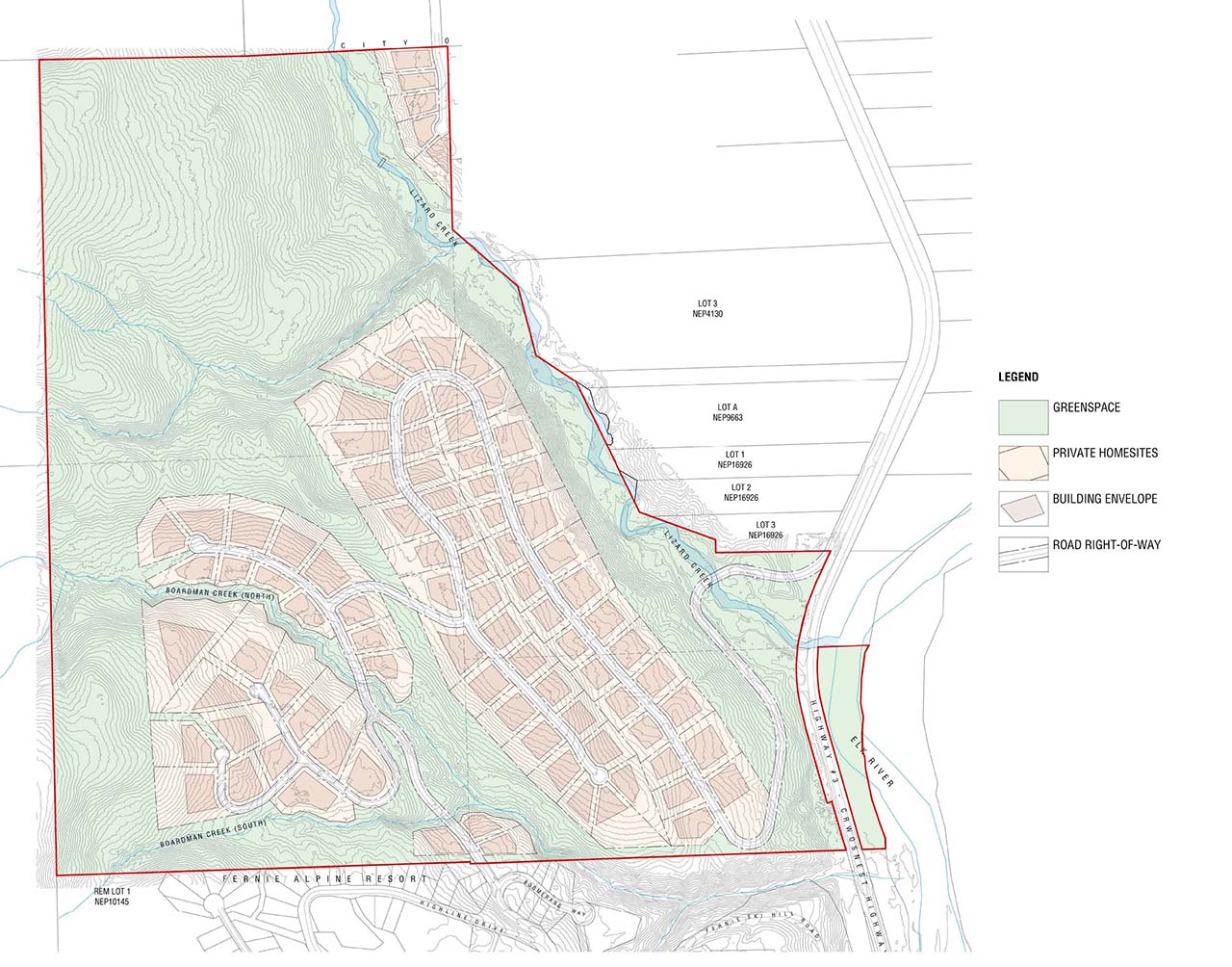
CONCEPTUAL DEVELOPMENT PLAN
The conceptual site plan illustrates a total of 90 homesites with a minimum 0.4 ha (1.0 acre) parcel area. Approximately 79 ha (195 acres), representing 42% of the property, is proposed for development of residential lots and roads. The remaining 106 ha (262 acres), representing 58% of the property, is proposed for conservation and recreation.
Access is proposed via a new road from Lizard Creek Road and Highway #3 with secondary access from Snow Pines Road (via Boomerang Drive and Highline Drive).
All lots will be connected to a community water and sewer system. This system will also provide fire flows to hydrants to be located within the development.
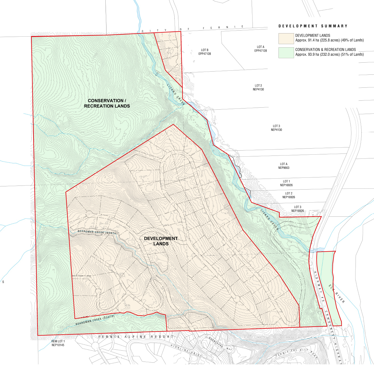
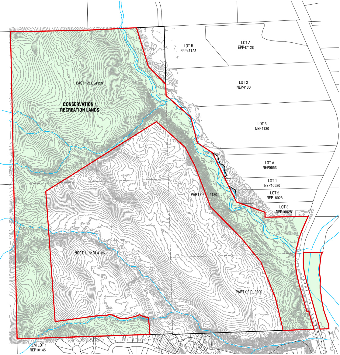
Conservation/ Recreation Lands
The applicant is proposing to transfer a large contiguous portion of the lands to a conservancy organization with the mandate to protect these lands in perpetuity while permitting non-motorized recreational use consistent with maintenance of the lands’ conservation values.
The total area of the lands to be transferred to the conservancy organization is approximately 94 ha (232 acres), representing 51% of the total Galloway Lands.
The conservation organization, in its capacity as landowner, will be willing to enter into a lease or other agreement with Fernie Nordic Society and other community groups to allow for access, maintenance, design, and development of Nordic ski trails and other multi-use trails, including mountain bike trails.
- click on image to zoom
- click on image to zoom
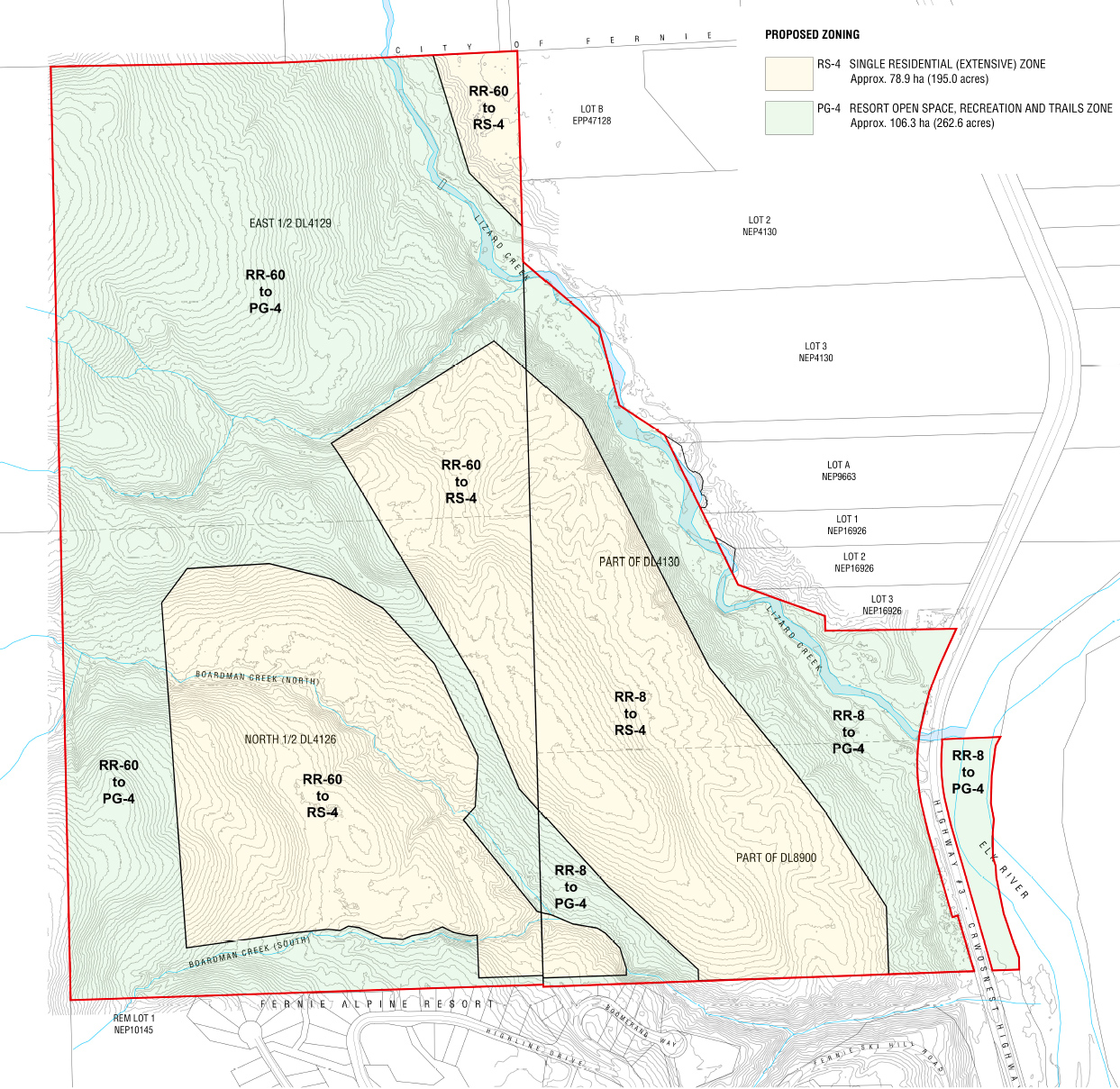
PROPOSED ZONING AMENDMENT
Amendments to the RDEK Elk Valley Zoning Bylaw are required to permit the proposed development. The land uses proposed are complementary to neighbouring land uses and ensure development is consistent with the conceptual plans presented in this application.
PG-4 I Resort, Open Space, Recreation and Trails Zone
An area comprising approximately 106 ha (262 acres) is proposed to be zoned PG-4 (Resort, Open Space, Recreation and Trails Zone). This zone comprises approximately 58% of the total lands and ensures the long-term protection of the Lizard Creek riparian corridor and other riparian corridors, the parcel of land east of Highway #3 along the Elk River and a significant buffer along the Crown lands to the west and Mt. Fernie Provincial Park to the north.
RS-4 I Single Family Residential (Extensive) Zone
Lands proposed for residential development are to be zoned RS-4 (Single Family Residential (Extensive) Zone). The RS-4 zone permits single family residential development on parcels not less than 0.4 ha (1.0 acre). A total of approximately 79 ha (195 acre ), representing approximately 42% of the parcel area is to be zoned RS-4.
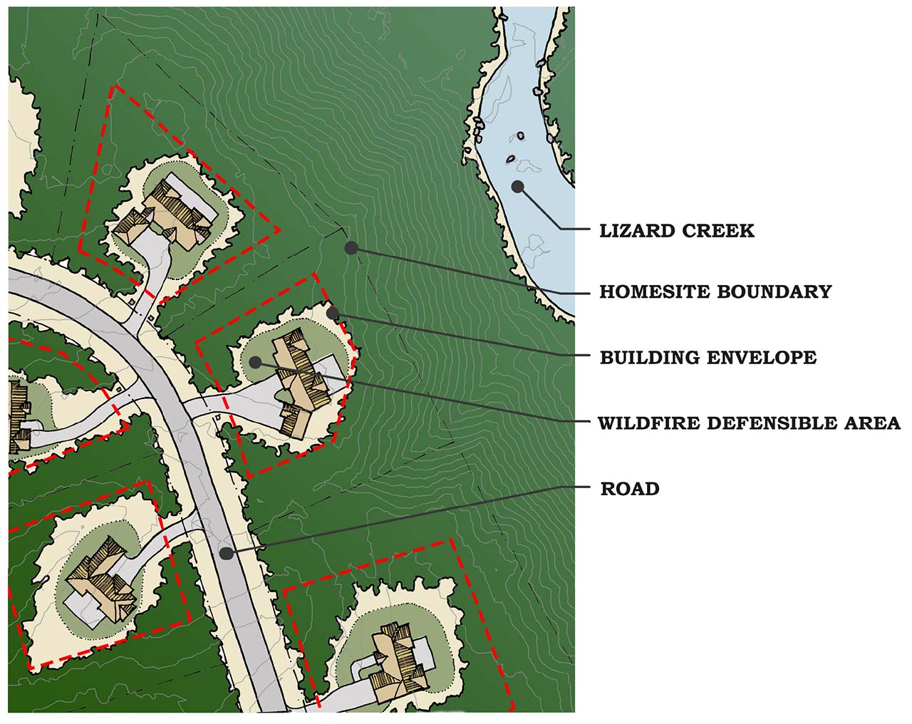
RESIDENTIAL DEVELOPMENT
BUILDING ENVELOPES
Each building lot will include a building envelope that must contain all development proposed on the lot, including the home, outbuildings, driveway, and landscaping.
The building envelope is the maximum area of each lot that may be utilized for residential development.
The only permitted uses outside of the building envelope will be the driveway between the frontage road and the building envelope.
- click on image to zoom
- click on image to zoom
INFRASTRUCTURE
ROADS/WATER/SEWER
Infrastructure for development of the lands will be provided in accordance with requirements of the Regional District of East Kootenay, BC Ministry of Transportation and Infrastructure, BC Hydro and other utility providers.
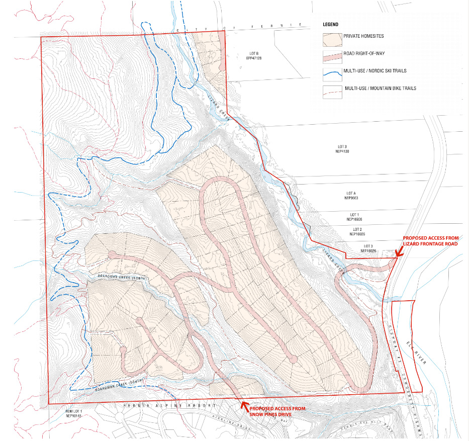
The road network within the Galloway Lands is proposed to be private. Access to the development is proposed via two locations. The primary access to the development will be a new road from Lizard Creek Road and Highway #3. A secondary access will be provided from Snow Pines Drive /Boomerang Way.
Water and sewer will be provided to all residential lots from the Fernie Alpine Resort water / sewer system. Water service will include both domestic service to lots and fire hydrants as required by RDEK Subdivision Servicing Bylaw.
- click on image to zoom
DEVELOPMENT COVENANTS
Covenants are proposed to ensure development proceeds as outlined in our land use application.
These covenants will be confirmed by the RDEK prior to issuance of subdivision approval and/or issuance of building permits.
The applicant proposes to register a Development Agreement containing these covenants prior to adoption of zoning.
The following covenants are proposed:
- Development of the lands must be in substantial compliance with the current site plan.
- Development of these lands is contingent on provision of water from a community water system. We are proposing to prohibit subdivision of any residential lot unless that lot is serviced by a community water system constructed in accordance with RDEK Subdivision Servicing Bylaw No.1954. Note that all subdivisions in the RDEK that are serviced with community water must also provide fire hydrants and other fire protection measures in accordance with RDEK Subdivision Servicing Bylaw No.1954.
- Development of these lands is contingent on provision of wastewater (sewer) service from a community wastewater system. We are proposing to prohibit subdivision of any residential lot unless that lot is connected to a community wastewater system constructed in accordance with RDEK SubdivisionServicing Bylaw No.1954.
- Registration of a ‘no build’ covenant over that portion of each residential lot which lies outside of the identified building envelope.
- Registration of a ‘statutory right of way’ over a private road through the Galloway Lands for use as an emergency access route to / from Fernie Alpine Resort.
- Registration of a ‘statutory right of way’ over the conservation / recreation portion of the lands ensuring public access and connectivity from Fernie Alpine Resort to Mount Fernie Provincial Park.
- Requirement for an Environmental Management Plan to be completed for the development and the plan will be submitted to the RDEK prior to subdivision of any residential lots.
- Creation of the Conservation / Recreation Lands parcel. We are proposing to prohibit subdivision of any residential lots until the Conservation Recreation Lands, defined by a red line in the adjacent plan, are created by subdivision as a titled parcel.
- Requirement for a Traffic Impact Assessment prior to subdivision.
- click on image to zoom
FAQ
The land is currently operated as a managed forest and would be logged at such time as the timber is merchantable. The land is currently zoned RR-60 and RR-8 which means that it could be used for a variety of options from residential to industrial; from farming to logging. Shifts to these uses could be implemented with no zoning change.
It’s important to note – if this happened, the land would not be protected as it would be under this proposal.
We are excited to announce that 51% of the overall holding will be zoned PG-4 which preserves the land by zoning it a park. Of this, 20% of the land will be preserved as a forested area. Through these measures we’ll be protecting important wildlife habitats and recreation trails.
Cascade Environmental Resource Group Ltd. assessed potential impacts of the proposed project to animal movement in an Environmental Overview Report which was published November 2, 2022. Earlier on March 25, 2022, Cascade examined studies carried out by Dr. Clayton Lamb as well as Procter et. al (2015). Both studied grizzly bear movement patterns. The Procter et al. (2015) report was based on an analysis of a large area which showed that Galloway Lands have moderate movement potential limited to the southeast corner, near the ski hill, while most of the site has low movement corridor potential. The Lamb study suggested that grizzly bears commonly use the Galloway Lands as a movement corridor. However, Dr. Lamb’s study was based on an analysis of a small area which showed an isolated high quality habitat patch in May-July surrounded by low quality habitat. Analysis of small area highlights a few bears moving through an area but this does not make it a movement corridor.
In terms of the importance of the Galloway Lands for winter range for deer, elk and moose, Cascade noted that the presence of a potential winter range on the site should not be a constraint to the development. In addition, the proposal has the set aside 232 acres of the parcel that would itself be conducive to use as winter range.
A review of cumulative effects was conducted. It involved a review of all available materials published on the subject. The conclusions were contained firstly in Cascades memo of March 2022 and later in the November 2022 report. A further summary was published on April 21, 2023, which contained a summary of the cumulative effect of the proposal.
The conclusion was that the total development would represent a small area (less than 0.01%) of the built-up area in the Elk Valley. The Galloway Lands is unlikely to contribute to cumulative effects on grizzly bears. Secondly, should adequate environmental management measures be followed the proposed development is unlikely to contribute to cumulative effects on aquatic habitat or old growth forest.
Yes. Cascade assessed potential impacts of the proposed project to wildlife. In the March 25, 2022 Technical memo, Cascade examined studies carried out by Dr. Lamb as well as Procter et. al (2015). Both studies analyzed telemetry data and modeled grizzly bear movement patterns.
The Procter et al. (2015) was based on an analysis of a large area which showed that Galloway Lands have moderate movement potential the southeast corner while most of the site has low movement corridor potential. The Lamb study suggested that grizzly bears commonly use the Galloway Lands as a movement corridor. However, Dr. Lamb’s study was based on an analysis of a small area which showed an isolated high quality habitat patch in May-July surrounded by low quality habitat. Analysis of small area highlights a few bears moving through an area but this does not necessarily make it a movement corridor.
In terms of the importance of the Galloway Lands for winter ungulate range it is important to note that the presence of a potential winter ungulates range on the site should not be considered a constraint to the development given the nature of the ownership. In addition, the proposal has the set aside a vast portion of the overall parcel that would itself be conducive to the presence of winter ungulates. The conclusion to draw from the environmental overview is that all in all the parcel lends itself to the type of conservation development being proposed.
The recommendations from the Cascade report will form the basis for an Environmental Management Plan as a requirement of the Development Agreement with the RDEK. That plan includes the requirement to have a Qualified Environmental Monitor oversee the project during construction.
Recommendations provided in the Cascade Environmental Report will form the basis for an Environmental Management Plan as a requirement of the Development Agreement with the RDEK. A Qualified Environmental Monitor will oversee the project during construction.
Yes. As a result of our public engagement, we have updated our plan to guarantee access to Galloway Lands park area through a statutory right of way on the parcel of land being preserved. This right of way will include a multi-use, machine groomable trail connecting Fernie Alpine Resort to Mt Fernie Provincial Park.
We have made a commitment to preserve 70% of the natural area – this includes the current trails. As well, the development creates a framework for the ongoing use of trails plus the creation of new trails.
This concern stems from a previous application that proposed each home would have its own wells and septic systems. We have brought forward a new application with a commitment to connect to the existing water and sewer utilities at the Fernie Alpine Resort.
The manager of that utility has confirmed that there is capacity to accommodate the Galloway Lands plan.
Since beginning our outreach in April of 2021, we have had engagement or attempted engagement with Ministry of Transportation and Infrastructure, BC Parks, City of Fernie, Ktunaxa First Nation, Tobacco Plains Band, Fernie Alpine Resort, Snow Valley Community Association, Fernie Nordic Society, Fernie Trail Alliance, Elk River Alliance, and Wildsight.
We also held two Open House presentations on March 30 and April 1, 2023, which attracted over 100 people. The feedback was polite and focused on environmental protection, affordable housing, and access.
We have made a few updates, these include:
- We have rethought the road access which will now come from an intersection at Lizard Creek Rd and Highway 3. We will no longer rely on existing ski hill access.
- Water and sewer now come from the Fernie Alpine Resort Utilities Company. We’ve committed that all construction traffic to come from the new access and avoid ski hill road network.
- We have guaranteed access to Galloway Lands park area through a legal agreement on the parcel of land being preserved. This right of way will include a multi-use, machine groomable trail connecting Fernie Alpine Resort to Mt Fernie Provincial Park.
By providing more supply of single-family housing, Galloway Lands will reduce the pressure on existing housing availability in the Fernie area. This zone request also allows for secondary suites, and this will provide an opportunity to create some additional supply.